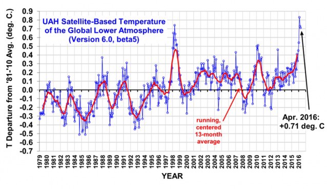
This was the hottest four-month start (January to April) of any year on record, according to newly-released satellite data.
The Arctic continues its multi-month trend of off-the-charts warmth. So it’s no surprise that Arctic sea ice continues to melt at a record pace. New research, however, finds that warming-driven Arctic sea ice loss causes high-pressure systems to get stuck in places like Greenland, leading to accelerated melt of the land-locked ice that drives sea level rise worldwide.
Let’s start with the University of Alabama at Huntsville (UAH) satellite data, which show that the lowest part of the atmosphere (the lower troposphere) was an impressive 1.3°F (0.71°C) above the historical (1981–2010) average — a baseline that is itself 0.8°F (0.45°C) hotter than pre-industrial levels.

April just about tied the record for hottest April in the satellite record (which was 0.73°C). It follows the hottest March, hottest February, and “warmest January in satellite record.”
So it’s easily been the hottest start to any year in the satellite record. Sorry Ted Cruz and other climate science deniers — we are observing human-caused global warming in every single dataset, including the satellites.
This year has also set records for loss of Arctic sea ice. Here is a chart of Arctic sea ice extent from the Danish Meteorological Institute (2016 is in black):

You can see an Arctic “death spiral” chart here. Leading cryo-scientists discuss whether 2016 will beat the record lowest sea ice extent that we saw in 2012 in this video.
Climate models have always predicted that human-caused warming would be at least twice as fast in the Arctic as in the planet as a whole thanks to Arctic Amplification — a process that includes higher temperatures melting highly reflective white ice and snow, which is replaced by the dark blue sea or dark land, both of which absorb more solar energy and lead to more melting. And that means some winters are going to see truly astonishing Arctic warmth, such as we’ve already observed this year (see my March post, “Record-Shattering February Warmth Bakes Alaska, Arctic 18°F Above Normal”).
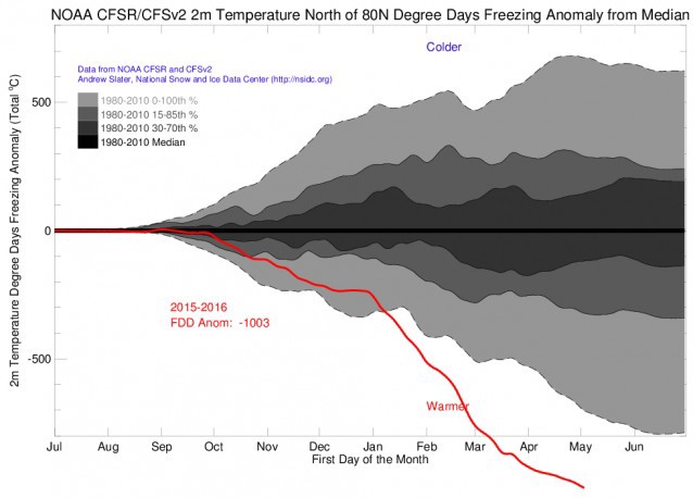
The record Arctic warming has continued, as indicated by freezing degree days (FDD), “a measure of how cold it has been for how long. The cumulative FDD is simply daily degrees below freezing summed over the total number of days the temperature was below freezing.”
This chart from cryo-scientist Andrew Slater shows how unusually warm 2016 has been compared to other years (at 80 degrees North latitude). I realize we expect charts to show warmth with a rising line. In this case, though, since the (lower) lines measure lack of cold — i.e. how anomalously few freezing degree days there have been — the lower a line on the chart is, the warmer it has been.

Considerable research finds that rapid Arctic warming, driven in part by sea ice loss, is already worsening extreme weather. And a new study links that extreme weather — in the form of high pressure systems that get stuck and act like a brick wall, “blocking” the weather from changing — to the accelerating loss of land-locked Greenland ice scientists have observed. The study, “Has Arctic Sea Ice Loss Contributed to Increased Surface Melting of the Greenland Ice Sheet?” explains why: “Reduced summer sea ice favors stronger and more frequent occurrences of blocking-high pressure events over Greenland.”
The researchers found “a positive feedback between the variability in the extent of summer Arctic sea ice and melt area of the summer Greenland ice sheet, which affects the Greenland ice sheet mass balance.” That’s why we have been seeing both more blocking events over Greenland and faster ice melt.
I asked co-author Professor Jennifer Francis of Rutgers, a leading expert on the connection between Arctic amplification and extreme weather, to summarize the findings. She explained:
Our new study does indeed add to the growing pile of evidence that amplified Arctic warming and sea-ice loss favor the formation of blocking high pressure features in the North Atlantic. These blocks can cause all sorts of trouble, including additional surface melt on Greenland’s ice sheet (the primary focus of this study) as well as persistent weather patterns both upstream (North America) and downstream (Europe) of the block. Persistent weather can result in extreme events, such as prolonged heat waves, flooding, and droughts, all of which have repeatedly reared their heads more frequently in recent years.
What happens in the Arctic does not stay in the Arctic.
