We know that global warming makes hurricanes more destructive in several ways — stronger winds, higher storm surge, much more precipitation.
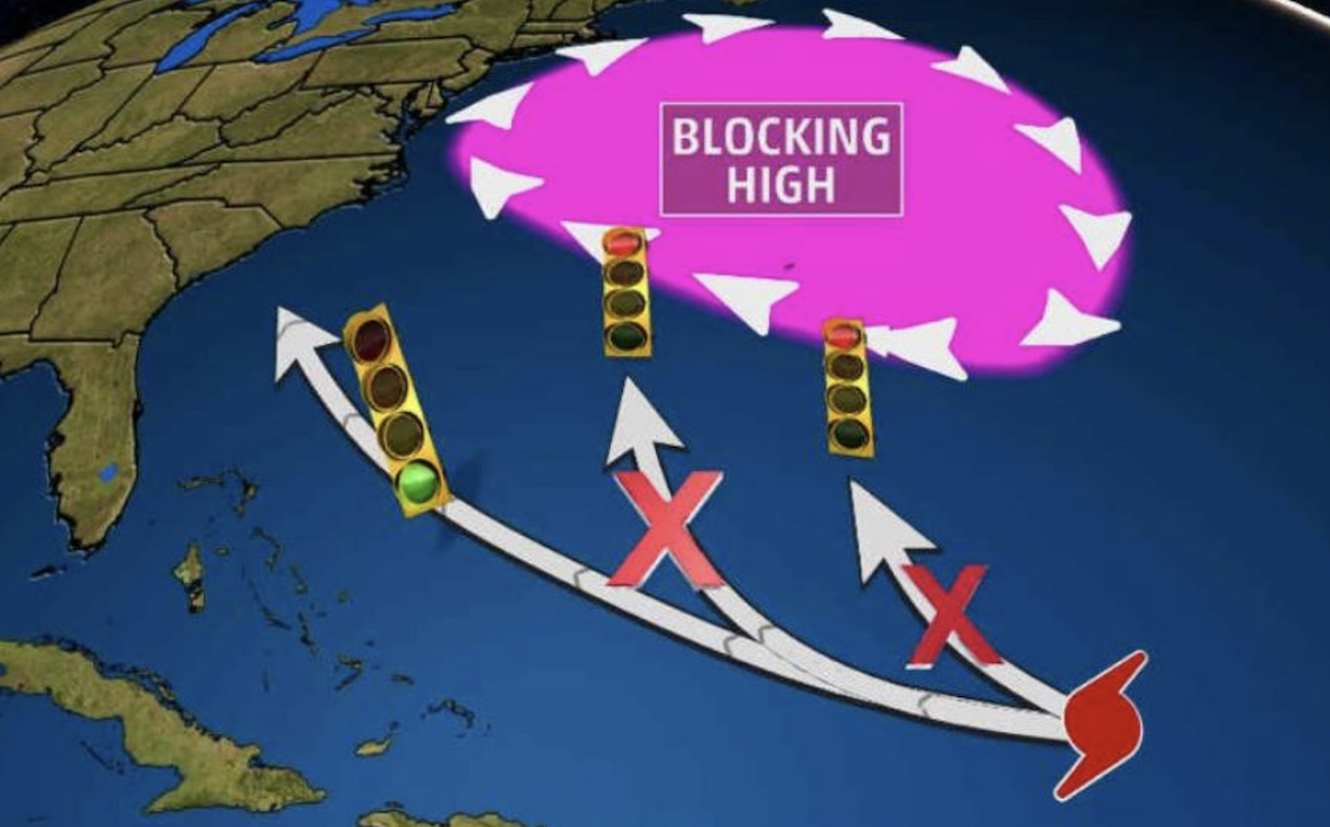
But can global warming actually steer a storm into a more deadly path? The growing evidence is that it can — and already has — by creating more powerful high-pressure systems that remain almost stationary and divert a cyclone from what would have been its normal path.
“It’s possible that the Arctic [warming] may be having a double-whammy effect that is favoring an increased frequency of blocking highs like the one that’s steering Florence in a highly unusual path, and like the one that did the same to Sandy,” as Dr. Jennifer Francis explained in an email to Think Progress.
The high-pressure system in the atmosphere, in effect, appears to be blocking the path of Hurricane Florence, and instead leading it directly towards landfall rather than allowing it to veer northwards into the Atlantic.

Francis, of Rutgers University’s Institute of Marine and Coastal Sciences, is one of the world’s leading experts on the connection between climate change, Arctic warming, and extreme weather events.
The path of Florence has been extremely unusual. As Philip Klotzbach, an Atlantic hurricane expert, tweeted on Friday, “33 named storms (since 1851) have been within 100 miles of Florence’s current position. None of these storms made US landfall. The closest approach was Hurricane George (1950) — the highlighted track [in white].”
33 named storms (since 1851) have been within 100 miles of #Florence's current position. None of these storms made US landfall. The closest approach was #Hurricane George (1950) – the highlighted track. However, Florence does not appear to be taking a climatological track. pic.twitter.com/4x02pasgPg
— Philip Klotzbach (@philklotzbach) September 7, 2018
Florence, tragically, has made a beeline toward the Carolinas. And it clearly was steered away from the historical (or “climatological”) path by a major high-pressure system blocking its typical path — north and away from land.
But why has this happened now and not before?
ThinkProgress asked Dr. Francis that question. She explained that “the science of blocking highs is a hot research topic. Climate models tend to underestimate their frequency compared with observations, which suggest they’re occurring more frequently in the North Atlantic during summer months.”
Back in 2016 Francis published a study on the link between blocking highs and global warming. At the time, she told ThinkProgress: “Our new study does indeed add to the growing pile of evidence that amplified Arctic warming and sea-ice loss favor the formation of blocking high pressure features in the North Atlantic. These blocks can cause all sorts of trouble…”
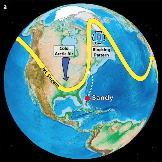
In her previous work into how global warming worsened superstorm Sandy, Francis and co-author, Charles Greene, director of Cornell’s Ocean Resources and Ecosystems program, argued that warming may have been responsible for Sandy’s unusual storm track.
As Cornell University explained their findings:
Cornell and Rutgers researchers report in the March issue of Oceanography that the severe loss of summertime Arctic sea ice — attributed to greenhouse warming — appears to enhance Northern Hemisphere jet stream meandering, intensify Arctic air mass invasions toward middle latitudes, and increase the frequency of atmospheric blocking events like the one that steered Hurricane Sandy west into the densely populated New York City area.

Figuring out all of the causes is tricky, Francis told ThinkProgress Tuesday, but “certainly the uptick [in blocking highs] is consistent with expectations in a world with rapid Arctic warming, which tends to weaken jet-stream winds and favor a more meandering path. Large northward swings can break off in an eddy, forming a blocking high.”
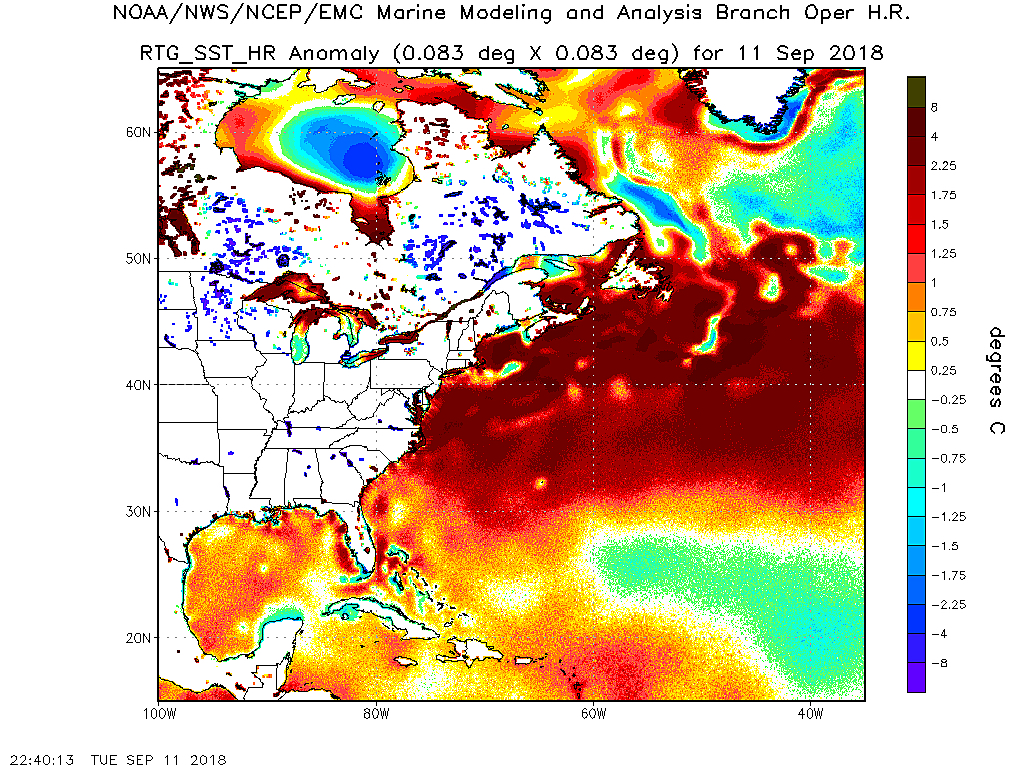
Another factor with Florence, she explained, “is the massive area of much warmer-than-normal ocean temperatures off the eastern seaboard of North America, which also favors those big northward jet-stream swings, and thus blocking highs.”

Francis notes that this large pool of warm water currently sitting in the Atlantic is similar to the one seen in the eastern Pacific that helped cause a blocking high directly linked to global warming that was also a major driver of the multi-year drought California suffered in recent years.
As NOAA’s map above shows, not only are sea surface temperatures off the East Coast very warm, but there is a pool of cool water just south of Greenland. Francis explained that this pool — created by the staggering amounts of melting ice from global warming — may also be contributing to a blocking high:
Interesting new twist: some new research suggests that the “cold pool” in the North Atlantic is caused by an influx of freshwater from the Arctic Ocean and Greenland meltwater, and that freshwater cap is backing up the flow of warm Gulf Stream water. So it’s possible that the Arctic may be having a double-whammy effect that is favoring an increased frequency of blocking highs like the one that’s steering Florence in a highly unusual path, and like the one that did the same to Sandy.
The bottom line: As global warming alters weather patterns, weakens the jetstream, and creates more powerful blocking highs in the North Atlantic, the East Coast may, unfortunately, see more major hurricanes steered toward the land, rather than away from it.
And the consequences of that change in climate already appears to be catastrophic.

