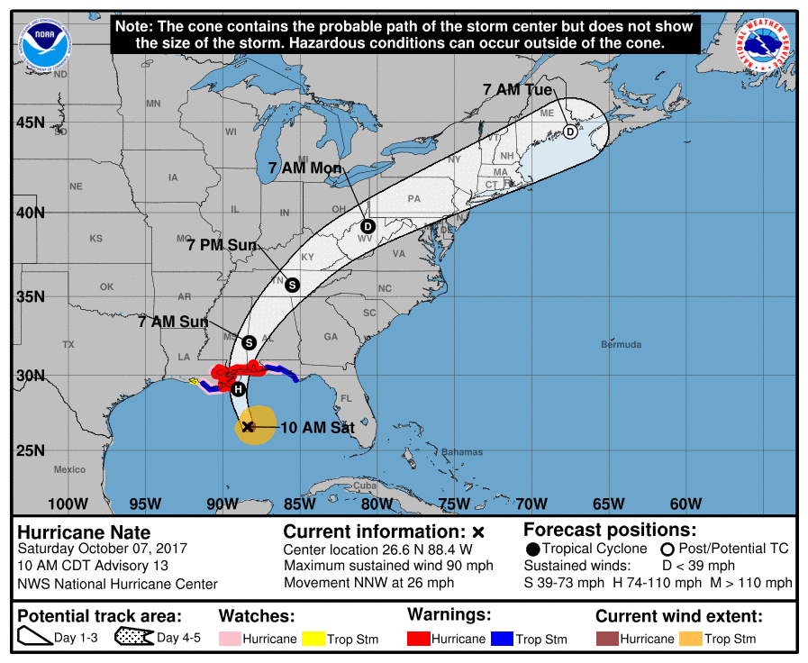
Hurricane Nate, which the National Hurricane Center upgraded to a Category Two hurricane Saturday morning, was projected to make landfall on the northern Gulf Coast Saturday evening. This will be the fourth hurricane to make landfall on the United States this year.
The storm killed a reported 25 people in Central America as it strengthened, mostly in Nicaragua and Costa Rica amid rising floodwaters and mudslides. Heavy rainfall, hurricane-force winds, and storm surge boosted by sea level rise are expected to be the storm’s main impacts. As of Saturday afternoon, Nate had already generated wave heights of 28 feet in the Gulf. It is already one of the fastest-moving storms on record.
Tonight's full moon high tide will arrive around midnight in coastal MS, just as #Nate is making landfall.
A worst-case for this storm.— Eric Holthaus (@EricHolthaus) October 7, 2017
Landfall is expected just as a full moon high tide arrives in coastal Mississippi at midnight, which will boost the storm surge even higher, as meteorologist Eric Holthaus noted.
A hurricane hunter aircraft measured the hurricane’s eye at 25 miles across, with most of the storm’s precipitation on the eastern edge, meaning Alabama and Mississippi were likely to bear the brunt. A Category Two hurricane has winds ranging from 96 to 110 miles per hour.

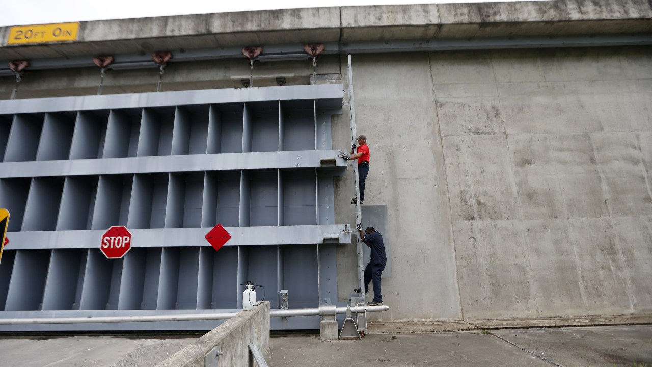
The National Hurricane Center issued hurricane warnings from Louisiana’s Grande Isle east to the Florida/Alabama border, including New Orleans. Parts of the region are under evacuation orders. Most oil and gas production in the Gulf went offline in advance of the storm. New Orleans’ pumping systems have been heavily taxed by recent heavy rain events — events that become more intense as the planet warms — and 11 of the city’s pumps were out of order as of Saturday morning, according to the Washington Post.
The U.S. Coast Guard ordered major ports from New Orleans to Florida’s panhandle to be shut to all inbound and outbound traffic as of 8 a.m. Saturday morning. Shutting the port that sits at the mouth of the Mississippi River will have ripple effects throughout the country, though the ports are expected to reopen after the storm passes by Saturday night.
The storm will also bring heavy precipitation well inland, and wind gusts could threaten power outages as far north as Tennessee.
Important update…#Nate power outage likelihood expanded north into southern TN, north AL, Sunday, given fast fwd speed, higher intensity. pic.twitter.com/RBZCTi6mPb
— Jonathan Erdman (@wxjerdman) October 7, 2017
The Trump administration, still smarting from criticism of its handling of disaster response to Hurricanes Harvey, Irma, and especially Maria, is eager to let people know they are preparing for Nate.
Last night, @POTUS approved an emergency declaration for LA to support emergency services like protecting lives & property. #HurricaneNate pic.twitter.com/e7upQgYTiv
— FEMA (@fema) October 7, 2017
Our great team at @FEMA is prepared for #HurricaneNate. Everyone in LA, MS, AL, and FL please listen to your local authorities & be safe!
— Donald J. Trump (@realDonaldTrump) October 7, 2017
Our 6ft 6in MIC next to 11ft poll. THAT'S how high water could get along coast MS River to MS/AL line. If under evac order, LEAVE NOW! #Nate pic.twitter.com/q15ruUyetE
— NWS New Orleans (@NWSNewOrleans) October 7, 2017
Many residents and businessowners in the Gulf are taking no chances with Nate’s potential for damaging coastal flooding and storm surge.
In low-laying Spanish Fort, AL, 5’-10’ is #stormsurge expected. This restaurant clearing out first floor in preparation of #HurricaneNate. pic.twitter.com/PXkueDxOCZ
— Justin Michaels (@JMichaelsNews) October 7, 2017
Blocking the #BankheadTunnel leading into #Mobile, AL ahead of #HurricaneNate, nine 1.5 ton sandbags. Live at 11AM/ET on @weatherchannel. pic.twitter.com/u7Vhy86TKy
— Justin Michaels (@JMichaelsNews) October 7, 2017
Our amazing electronics staff getting our building ready for #Nate. We are ready, are you? pic.twitter.com/QInA3H9pPy
— Ken Graham (@wx4keg) October 7, 2017
While Hurricane Nate is certainly not the most destructive storm to hit the United States this year (Harvey, Irma, and Maria each topped out at Category 5 before usually weakening slightly when they made landfall), it is rare to have a Gulf storm like Nate make landfall so late in the year. It is the ninth hurricane to form in the Atlantic so far this year. That’s the highest number since 2012, when Sandy devastated the Northeast. Hurricane season ends November 30.
As Donald Trump said last month, “It’s just one after another” this hurricane season. Even if this particular storm is not as cataclysmic as others, the aggregate impact of recovering from several storms across the country can be debilitating, as the residents of Puerto Rico have discovered with Hurricane Maria. It’s even more difficult when parts of an administration are actively hostile to the basics of climate science, let alone being less willing to take climate change into account when planning rebuilding efforts
September was the most active month on record for Atlantic hurricanes, as measured by the Accumulated Cyclone Energy (ACE) Index. Adding yet another hurricane to the mix will push the yearly index score higher, which is something that climate scientists watch as they track the ever-increasing ocean water temperatures that help to fuel intense storms and allow them to last longer.
#Nate is a Cat. 1 hurricane w/ sust. winds of 90 MPH. @NHC_Atlantic expects landfall tonight as a Cat. 2 w/ 105 MPH winds. @NOAA #GOES16 pic.twitter.com/rknKze0zIm
— NASA SPoRT (@NASA_SPoRT) October 7, 2017
