After heavy rain patterns tore up the Eastern Seaboard Tuesday, the tri-state area surrounding New York City found itself grappling with an “intense, historic” storm, according to WPIX. The rain had slackened off by late morning, but not without leaving power outages, downed trees, severe flooding, and damaged and abandoned cars and infrastructure.
The National Weather Service declared a Flash Flood Warning through the morning, calling the situation “dangerous and life-threatening.” Suffolk County Executive Steve Bellone labeled it “a storm of historic proportions.”
Long Island’s Suffolk County was particularly drenched, with the town of Islip receiving prodigious amounts of precipitation. Islip’s daily rainfall record was 6.7 inches, and by just after 8 a.m., 13 inches of rain had fallen on the town. Five inches fell between 5 and 6 a.m, and 9.71 inches between 5 and 7. Highways, including sections of the Long Island Expressway, closed as drivers abandoned cars and some had to be rescued in boats. The Long Island Rail Road experienced serious delays, and many commuters just gave up and went back home.
Suffolk County Executive Steve Bellone called it “a storm of historic proportions.”
A person reportedly died on the Long Island Expressway near Dix Hills early Wednesday morning after a tractor trailer hit a slower-moving SUV during the worst of the storm.
Millville is a town in southern New Jersey, and it saw nine inches fall, flooding streets up to five feet deep. According to the Red Cross, six people were displaced when a building collapsed, and following a suspected gas leak, another family (with six dogs) was evacuated from their home.
Branford, Connecticut’s stretch of I-95 saw many of its cars submerged, according to the Weather Channel. With storm drains backed up from all the water, many are dealing with inches of water in their backyards and homes. Some homeowners in Old Saybrook say they expect the water to stick around for days.
“We might go kayaking in the backyard later,” a young girl told WTNH.
A large area south of Baltimore, Maryland got hit by eight inches of rain on Tuesday afternoon, delaying flights at BWI airport and immersing cars parked in the long-term lot halfway underwater. It was the second-highest rainfall total ever for the location. Northern Anne Arundel County received ten inches of rain on Tuesday.
As the atmosphere traps more heat due to greenhouse gases, two big things happen. The extra heat warms the oceans, which allows more water to evaporate into the atmosphere. The other thing that happens is that the air stays wetter for longer. Warmer air can hold more water than cooler air, so there is more capacity for that water vapor to stay as potential rain.
This leads to precipitation events being more extreme — when it rains, it actually does pour more. Drier areas tend to get drier because that warmer air can hold more moisture, leading to fewer events of more moderate rainfall. When conditions allow for clouds and rain to form, that air is going to have more moisture to fuel a storm event, leading to more severe downpours.
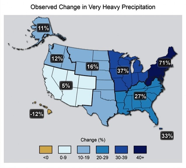
In May, the National Climate Assessment warned of likely climate impacts in different regions. Near the top of the list for the Northeast is flooding — not just from sea level rise, but from severe precipitation events. Fully 71 percent more precipitation falls in the heaviest rain events now than it did in 1958.

Canada’s senior climatologist, Dave Phillips, said last week that governments can no longer plan for the “normal” rain patterns observed over the last 100 years. “These [once in] 50-year floods are occurring every 10 years, because our climate has changed.”
While the Pacific Northwest and California grapple with hot weather, wildfires, and drought, serious downpours have hit states east of the Rockies in the last week.
On Monday and Tuesday, Detroit suffered the heaviest rains in almost a century. In one four-hour period, between four and six inches of rain fell on metro-area Detroit, shutting down major expressways and forcing drivers to abandon over a thousand vehicles on flooded roads. The town of Warren was the center of the deluge, and both its city hall and police station were flooded under six feet of water — the mayor declared a state of emergency in order to receive aid from the National Guard.
It got so bad that a police scuba dive team checked more than 70 vehicles on Interstate 94 on Tuesday morning to ensure drivers were not trapped inside submerged vehicles. Lt. Michael Shaw advised residents to “avoid non-essential use of the metro Detroit freeway system.” A 31-year-old seizure victim was found dead in her car, stalled by three-and-a-half feet of water. On Wednesday morning, however, the skies over Detroit were clear.
Over the weekend in Kearney, Nebraska, 3.5 inches of rain caused a flash flood that left up to 20 cars stalled on roads, in water that reached three feet deep. People standing on the flooded ground floor of the Good Samaritan Hospital had to run upstairs as a wave of water busted the doors open and roared inside.
