By Jeff Masters, via Weather Underground
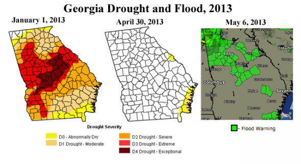
The remarkable storm that brought record-breaking May snows and cold to the Midwest last week continues to spin over the Southeast U.S. The storm is unleashing flooding rains, bringing a case of “Weather Whiplash” to Georgia: flooding where extreme drought had existed just a few months ago. The storm formed when a loop in the jet stream of extreme amplitude got cut off from the main flow of the jet over the weekend, forming a “cutoff low” that is now slowly spinning down as it drifts east over the Southeast U.S. On Sunday, the storm dumped 3.4″ of rain on Atlanta, Georgia — that city’s sixth heaviest May calendar day rain storm since record keeping began in 1878. Remarkably, the rains were also able to bring rivers in Central Georgia above flood stage. This portion of the country was in “exceptional drought” — the worst category of drought — at the beginning of 2013.
Figure 1. The record May snowstorm that hit the Midwest U.S. on May 1–3, 2013, got cut off from the jet stream and was seen spinning over the Southeast U.S. on Sunday, May 5, in this image from NASA’s MODIS instrument. The 3.4″ of rain that fell on Atlanta, Georgia on May 5 was that city’s sixth heaviest May calendar day rainfall since record keeping began in 1878.Weather Whiplash
Weather Whiplash — a term originally coined by science writer Andrew Freedman of climatecentral.org to describe extreme shifts between cold and hot weather — is also a excellent phrase we can use to describe some of the rapid transitions between extreme drought and floods seen in recent years. I brought up a remarkable example in mid-April, when a 200-mile stretch of the Mississippi River north of St. Louis reached damaging major flood levels less than four months after near-record low water levels restricted barge traffic, forcing the Army Corp to blast out rocks from the river bottom to enable navigation. As the climate warms, the new normal in coming decades is going to be more and more extreme “Weather Whiplash” drought-flood cycles like we have seen in the Midwest and in Georgia this year. A warmer atmosphere is capable of bringing heavier downpours, since warmer air can hold more water vapor. But you still need a low pressure system to come along and wring that moisture out of the air to get rain. When natural fluctuations in jet stream patterns take storms away from a region, creating a drought, the extra water vapor in the air won’t do you any good. There will be no mechanism to lift the moisture, condense it, and generate drought-busting rains. The drought that ensues will be more intense, since temperatures will be hotter and the soil will dry out more.

Figure 2. Weather Whiplash in Georgia, 2013: the center of the state was in exceptional drought as the beginning of the year, but heavy rains in February, March, and April busted the drought. Heavy May rains have now brought flooding. Image credit: U.S. Drought Monitor.Weather Whiplash in the Southeast U.S. more likely due to an intensification of the Bermuda HighThis year’s “Weather Whiplash” in Georgia is the second time in the past decade the state has gone from exceptional drought to flood. In September 2007, Atlanta, Georgia was in the midst of a 1-in-100 year drought, and was just weeks away from running out of water. Yet just two years later, the drought had been busted, and a phenomenal 1-in-500 year flood ripped through the city, killing ten and causing $500 million in damage. According to a 2011 study by a Duke University-led team of climate scientists, “Changes to the North Atlantic Subtropical High and Its Role in the Intensification of Summer Rainfall Variability in the Southeastern United States”, the frequency of abnormally wet or dry summer weather in the southeastern United States has more than doubled in recent decades, due to an intensification of the Bermuda High. The scientists found that the Bermuda High, which is centered several hundred miles to the east of the Southeast U.S., has grown more intense during summer and has expanded westwards over the past 30 years. Since high pressure systems are areas of sinking air that discourage precipitation, this has made abnormally dry summers more common over the Southeast U.S. However, in summers when the Bermuda High happens to shift to the east, so that high pressure is not over the Southeast U.S., the stronger winds blowing clockwise around the Bermuda High bring an increased flow of very moist subtropical air from the south to the Southeast U.S., increasing the incidence of abnormally wet summers. Thus, the intensification of the Bermuda High has made extreme droughts and extreme floods more likely over the Southeast U.S. Using climate models, the scientists determined that human-caused global warming was likely the main cause of the significant intensification in the Bermuda High. Thus “Weather Whiplash” between drought and flood will probably become increasingly common in the coming decades over the Southeast U.S.

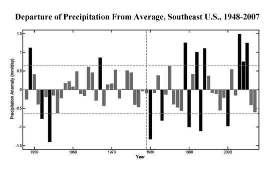
Figure 3. Observed June-July-August departure of precipitation from average over the SE United States for a 60-yr period (mm day−1). Horizontal dashed lines represent 1 standard deviation of the summer rainfall. Note that summer precipitation extremes exceeding one standard deviation have more than doubled during the most recent 30-year period compared to the previous 30-year period. Image credit: Li et al., 2011, Journal of Climate. — Jeff Masters is the co-founder of the Weather Underground. This piece was originally published at the Wunderblog and was excerpted with permission.
